
_.jpg)
Stonehenge Solutions

--Solving Stonehenge?
The Five Trilithons of Stonehenge
The familiar Horseshoe of five Sarsen Trilithons is the climax of Stonehenge. The following sections describe how the Trilithons are the heart and soul of the design and interpretation of the monument. From this point all other details of design and architecture would follow.
_j.jpg)
.jpg)
.jpg)
Notes and comment
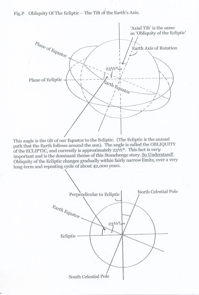
Some definitions
1). Equator of Earth is a line encircling the middle of our planet, midway between North and South poles. It is at right angles to the Polar Axis about which Earth revolves in space. Notionally the Equator can be projected outwards into the Cosmos to form a circle - the Celestial Equator - upon the backdrop of stars of the Celestial Sphere. With the Polar Axis it is the basis of astronomical systems to measure and fix the position of celestial objects - sun, moon, planets comets, stars, etc. Earth rotates, on its polar axis, once per day, and so any point on the backdrop of the Celestial Sphere passes a particular point on Earth, correspondingly, once per day.
2). Obliquity is a divergence of two lines. In this astronomical context it is measured as an angle.
3). Ecliptic is the apparent path that the sun follows as it appears to encircle the Earth once per year. The Ecliptic is tilted relative to the Celestial Equator by about 23.50 degrees. This is the approximate value that many people know. In fact this tilt is measured very precisely at any particular date and is changing very gradually with the passage of time. The very precise measurement of this angle is the basis of this section of the Stonehenge debate that involves the numerical value contained within the formation of the Trilithon Horseshoe.
The change in the ecliptic follows a very long-term cycle of c. 40,000 years.
4). Obliquity of the Ecliptic. is the apparent divergence, or angle, between the Equator of the Earth and the Ecliptic of the Sun.
Comment
1). Due to the structure and history of our solar system the occasions when Earth and sun are aligned in the correct arrangement to yield numerical Obliquity values shown above in relationship to the Stonehenge Trilithons that yield the mean value around 23* 40.5', and also with the date (year count) values with identical number value of 2340 (B.C. or A.D.) will be rare.
2). The fact that, in the very long history of our planet, our very short-lived human civilization, that originated a mere 14 - 12,000 years ago, happened to embark upon its technological development at the beginning of the 'Age of Metalworking' as this very rare Sun - Earth alignment happened is, in its own right, an astonishingly rare chance.
3). That an ancient, 'illiterate', and technologically naive civilization contrived to mark this once-and-for-all event with the once-and-for-all conception and construction of the Sarsen Trilithons at Stonehenge, not to mention the rest of the monument, is surely an even more extraordinary fluke.
4). Also we must add to these facts, that our modern year count numerical value coincides with the values so far described for the astronomy and the Stonehenge architecture as described by the one binary expression of the Trilithons. For this to be other than accidental would require that the year count was started at least 2340 years before years began to be counted!
5). The numerical value 23405 has yielded the two dates of B.C. 2340 and A.D. 2340. Elsewhere in the web-sites I show that there was a once-and-only conjunction of sun and the star Regulus c. B.C. 2340, and that this should be taken as the 'inauguration' date for Sarsen Stonehenge. B.C. 2340 and A.D. 2340 form the total year count between the two significant obliquity values. B.C. 2340 is, here, accounted for. What significance can be attached to A.D. 2340? It can be noted that mid-point of this year count of 4680 years is year 0. Year 0 was the nativity of Christ and the beginning of the Christian religion. (This will be to the despair of many people with a scientific turn of mind who take great pride in discounting and rubbishing all idea of religion, belief, faith, etc., because they can't 'prove it' by experiment! Confirmed atheists!)
There is a coincidence, here, of recent archaeological dating, modern astronomy, and 'modern' binary number expression, all 'wrapped' into one very ancient, megalithic, 'impossible' monumental construction
It is worth repeating the question: -- Is this coincidence of date, astronomy and architecture, (and, by implication, binary expression), an accidental coincidence, or is it designed and intended?
It would be as difficult to believe in the possibility of this happening by chance as it would envisioning the possibility of an Earth-type planet, in a remote corner of a distant galaxy eventually becoming inhabited by intelligent, homo-sapiens type beings.
==================================================================
The Ground Plan of the Trilithon and Bluestone Horseshoes. A series of concentric ellipses that set the layout of the whole central area of Stonehenge.
I have considered and described, within my web-sites, how the design of Stonehenge incorporated the horizontal ground plan altitude grid system. to define the relative positions of its constituent stone circles. Then by means of the vertical cross sections of the altitude grid system confirm the circle positions, and even establish the altitude for mid-summer sun / Regulus group crossing the main Stonehenge axis by selecting the height of the Great Trilithon archway (- uprights 55 - 56 and lintel) according to the ground position of the archway.
This has exploited two dimensions - horizontal and vertical - to describe how Stonehenge and its intended purpose were fitted into the overall astronomical situation of mid-third millenium B.C. How the incorporated knowledge could be demonstrated, 'fixed' , and passed forward to future generations. It has also given a general, overall astronomical context within which Stonehenge could be seen, interpreted, and within which the story that Stonehenge tells us could be further read and understood towards a specific time and event going forwards.
There is a third dimension that can also be found within the design of Stonehenge. Its basic principles are slightly more complex and advanced to establish. But the principle remains the same of locating and erecting stone formations to provide further astronomical context that ties in very neatly with that referred to above.
Scottish Professor Alexander Thom worked extensively during the 1960's and 1970's on surveying and accurately describing many megalithic monuments across the British Isles and Brittany. He produced and published much data and was universally respected for his insistence upon the importance of accuracy and precision in measuring and recording this.
His direction was more towards establishing stone-to-stone and stone-to-landscape alignments towards, particularly, lunar and solar events as seen from particular monuments. Also towards establishing whether and what was some 'universal' measuring system and measuring units used by the designers of these monuments. His results were generally respected by the wider scientific community for their quality, but generally not accepted on the grounds of 'not looking right', and as being 'too fanciful' and improbable for 'primitive' communities with only a 'primitive' knowledge base in Late Stone Age / Early Bronze Age times.
He spent time at Stonehenge. surveying and recording the monument to his own satisfactory standard of accuracy. One result of his work was the ground plan of Stonehenge which is here shown.

He identified, within the more obvious system of circles in the design, the system of ellipses that more accurately match to the basis of the design of the two Horseshoe formations -Sarsen Trilithon Horseshoe and innermost Bluestone Horseshoe.
From time to time during my own research into many aspects of the Stonehenge story I have attempted to resolve this question of why the two Stonehenge Horseshoes were designed as they were. Why did the builders erect these stones into these formations, and place them specifically where we see them today? The pattern of the Horseshoes that we now see is very neat, symmetrical about the Stonehenge Axis, and obviously carefully arranged. It cannot be fortuitous - a lucky coincidence - that the five Sarsen Trilithons and 18 /19 Bluestones finished up in these positions.
Therefore there was a plan! We can seek the explanation!
I have worked extensively to explain, justify, place in to the Stonehenge context, the ellipse system suggested by Professor Thom. However, sad-to-say, it has not been successful. There are some possibilities but they do not fit correct astronomical fact and therefore fail. But his general suggestion of ellipses has been the stimulus for my own conclusion that now follows. It is straightforward and astronomically easy. It appears to fit directly into the general context of Stonehenge. Bu it is also very advanced for Late Neolithic Britain - seemingly far too 'clever' for 'primitive' people to visualise.
I would guess that Professor Thom, in the early 2nd half of the twentieth century, had to do most of his geometry concerning Stonehenge manually and physically with ruler and assorted instruments. This is very hard work, trying to one's patience, and often frustrating. Merely to 'play around' with a particular ellipse and re-draw it slightly larger or smaller can be a daunting task - I have tried it myself.
Fortunately 21st century technology has now come to the rescue and it is a very easy, quick, accurate task to create simple geometric shapes on a screen. Then shuffle them, overlay, alter size and shape - print / save. Job done.
Therefore the ellipse system of Professor Thom is now put to one side and can be replaced by a variation on the ellipse theme. Having done so, other astronomical possibilities can be tested.

Fig.2 is the basic plan with just the significant axes. The compass axes (N,S,E,W) allow the plan to be linked to significant astronomy. The Stonehenge Axis towards the Heelstone allows astronomy and monument to be tied together in date / time and location and geography (latitude).

Fig. 3 Shows the Trilithon ellipse. Clearly the Horseshoe of Trilithons is the central, greatest feature of Stonehenge and therefore this is the most likely place to find any significant data or plan.
Fig. 3 shows the ellipse that encompasses and embraces the five Trilithons most comfortably. This ellipse 'holds' the four side Trilithons equally and then just encloses the Great Trilithon - uprights 55 - 56. At the 'entrance' end it touches on to the faces of the two major Bluestones of the 'entrance' to the Bluestone Circle.
(The Bluestone Circle is usually considered to have been erratically constructed - not an accurate circle. But if any part was accurately laid out it would most likely have been the 'Entrance' sector that had a clear view from the central area and was, visually, most significant.)
Again it is fair to comment that , either the Trilithons just happened by pure chance and a lucky fluke, to be built to this layout and shape. Or that there was this plan and they were intentionally erected to it.
As a geometrical shape the Trilithon Horseshoe can be interpreted as a tipped circle tipped to an altitude of c. 39* above horizontal.

The Bluestone Horseshoe ellipse shown in Fig. 4 is, in shape and proportion, a very accurate echo of the Trilithon ellipse of Fig. 3, merely being at a smaller scale. Again the ellipse touches to the surviving stones of the Horseshoe and then encloses the small group that crosses the Axis line in front of the Great Trilithon. And this small Axis crossing group of Bluestones are not just enclosed but actually follow the curve of the end of the ellipse.
'Tweaking' the width / length slightly for, possibly, a 'better' fit would not affect the important fact of the overall shape. That is one of the great strengths of the Stonehenge design. Certainly this particular aspect, regardless of the ruinous condition and the potential irregularity of erecting great stones into various formations, still has the potential to allow for the extraction of quite accurate and therefore useful information.
The Bluestone ellipse echoes the Trilithon ellipse and can be interpreted as a tipped / tilted circle, tipped at 39* (38.6*) above horizontal. We now have a Stonehenge plan with two identically shaped ellipses fitted to the two central Horseshoes.
We can progress further. Stonehenge is about circles, tilted or flat. The outer Sarsen Circle is interpreted as representing the visible horizon at latitude 51* N (local horizon). Then we can observe, measure and record the altitude of Celestial Objects above this level, flat, local horizon. We can also deduce any Celestial Objects that were of interest to our Stonehenge designer by noting any altitude values that were especially the focus of the design plan.
The two ellipses as tipped circles at 39* are continuous and circular. This implies complete orbit - orbit tracks. Because they have been shown as ellipses, this implies that we are meant to see orbit tracks from an offset point outside of Earth. In our modern world we frequently see this kind of representation of circles in many areas, whether it be science, engineering, school maths, or whatever. We have no problem at all in forming this mental picture.
If the ellipses are Celestial orbit tracks we can assume that they are orbiting Earth - a solid sphere. Therefore we can add a circle to each ellipse to complete each picture.

Fig. 5 completes the picture with circles added to each ellipse.
We need to select circles of the correct size. The important point is to ensure that each circle intersects with its ellipse as they cross the east - west axis. This means that the orbit track - and therefore its celestial object - rises exactly east and sets exactly west. It is notable that adding the two circles on this basis results in circles for each Horseshoe that fit very neatly and logically to the respective stone formation, (The circles enclose their formations from corner to corner as far as corners are possible with half ruined Horseshoes. They could have crossed the formations here or there at random and with no logical arrangement, but, instead, fitted neatly. It is as though some person stood and instructed from a pre-determined plan as the position for each stone was marked.)
We now have orbit tracks at latitude 51* N tilted at 39* above horizontal, rising at due east and setting at due west. Therefore we have orbit tracks for the Celestial Equator. I have frequently described, within this work, how the Celestial Equator along with North and South Poles, are the basis of measuring, marking, and recording position of celestial objects / activity upon the Celestial Sphere.
Knowledge and understanding of these two is fundamental to understanding the fact of the existence and motion of planet Earth within space. Current academic knowledge asserts that this picture of Earth and Celestial mechanics was not known until several millenia after the time of the building of Stonehenge. But here there is a clear demonstration that it was known.

In Fig. 5(b) we can see just the simple ellipse / circle pair and their relationship to the two axis systems that define the basic skeleton of the plan of Stonehenge and upon which the whole of the rest of the monument was planned and built.
Too ensure that there is no confusion in interpretation this simple construction is duplicated in Bluestone pillars and then in Sarsen Trilithons. To the builders this was a tremendous undertaking and the fact that we can, more than four and a half thousand years later, extract so much meaning is testimony to their incredibly successful planning and achievement. It is absolutely imperative that we understand the magnitude of their achievement and correctly expect to deduce a comparable significantly important purpose to Stonehenge.
Having established the astronomical theme within the Horseshoes, we can ask the purpose. It seems to me that the purpose of constructing the Horseshoes to demonstrate the fact of the Celestial Equator achieves several points.
1). It proves that 'advanced' astronomical knowledge was available at this time, was understood, and could be manipulated, described, used as the basis for monumental construction. It proves that there was, in existence, an advanced understanding and picture of the Earth in space. If the proof does not now sit with received wisdom on what was the state of astronomical knowledge at this time, that is partly because academia has singularly failed to grasp the challenge of interpreting Stonehenge with a proper, mature mind-set. Perhaps academia would prefer not to contemplate problems that do not fit in with the accepted record of the development of human civilization. Perhaps people just cannot handle proof that they do not like!
2). The astronomical facts just shown within the Horseshoes provide more proof of the context within which Stonehenge was planned and built. This must lead on to demonstrating its intended function - the purpose for which it was built - surely the whole point of this exercise.
3). By putting this knowledge and cosmic picture at the heart of Stonehenge as the basis for the plans of the two Horseshoes it gives the particular fact of the picture of Earth within space as the central, dominant idea or theme to be followed in interpreting Stonehenge, rather than such concepts as solar, lunar, and planetary cycles and activity. These themes have been favourites amongst archaeo-astronomers for investigation in recent years. Stonehenge, its underlying themes and purpose, is bigger than our little local solar system. It reaches out and will lead us out into the greater Space beyond.
=======================================================================
Discussion concerning issues raised by the previous section on ellipses and various other connected issues.
In the foregoing section I have tried to pull out some clear fact concerning the geometry of circle and ellipse that may be contained within the original design for the two Horseshoes - Trilithons and Bluestone. It seems to work and to fit. The fit of each system with its particular Horseshoe seems too good to be accidental. The two systems duplicate each other very well. The combination of ellipse sides fitting closely to stone formation sides, and complementary circle circumference fitting to the crossing parts of the Horseshoes is, to me, intended.
Therefore I now have the information from the shapes of the two ellipses, of 'tipped' circles, tilted at c. 38* / 39* to horizontal ground surface. As the two Horseshoes are the central, focal point of Stonehenge. and almost certainly contain information that is of considerable importance to the story and purpose of Stonehenge, then it seems of some importance to try and postulate WHY and WHAT is the the meaning of contained information. The two stone formations did not just happen by chance.
The unified two Horseshoe systems do not share a common centre with the outer perimeter Sarsen Circle and the Bluestone Circle. This could also be perplexing. If there is astronomy represented within Stonehenge by an outer system of two circles and an inner system of two Horseshoes, then does this represent a 'shift' in something between the time / date implied by two disparate systems?
Through several millennia there are changes in astronomy due to: -
(1). Precession of the Equinoxes
(2). Change of Obliquity.
These are subtle changes to observed positions and timing of rising / culmination / setting of stars and constellations
(3). There is a more obviously visible change in position of the North Point, leading to gradual change of 'Pole Star' from one epoch to another.
(4). Also a change to the orientation of the Milky Way. The Milky Way would have been a very visual and significant celestial object to any early astronomer. It is rarely mentioned in other work on ancient astronomy.
None of these seem to fit with the two different centres of the two systems - circles and ellipse / circles. For now I conclude that the difference is purely to physically differentiate between the two different types of system. Therefore the two outer circles - Sarsen and Bluestone - remain as intended. The Sarsen Circle defines the local flat horizon. (The 'frame' for astronomy as seen from Stonehenge.) The Bluestone Circle represents the Celestial Equator. These two 'outline' the theme that Stonehenge is about Astronomy and events that occur within the sky above. So I am left with the same question - WHY circle / ellipse systems, and duplicated for confirmation.?
As seen they cannot easily be tied exactly to actual astronomy because of the ellipses laying along the Main Stonehenge Axis at azimuth c. 50 / 51* and 230 / 231*. To be correct they would need to lie exactly on one of the Compass axes - N/S or E/W.
It follows that they must be descriptive - figurative - representative. Therefore the reasoning is thus:-
(1). The ellipses represent tilted circles at c. 39*, which corresponds to the altitude of the Celestial Equator at Stonehenge.
(2). To achieve an astronomically correct orientation with one of the circle / ellipse systems it would be necessary to re-align the Main Stonehenge Axis, that contains the long axis of the ellipse. with one of the Compass axes.
(3). If the circle was seen as representing the sphere of the Earth, then the ellipse (Stonehenge) Axis would align with the N - S Compass Axis such that the greatest altitude of the Celestial Equator (39*) and the LONG axis of the ellipse would be at South.
(4). If the circle was seen as a flat representation of the local horizon at Stonehenge (as with the Sarsen Circle), then the Stonehenge Axis would need to align with Compass E - W. Then the maximum altitude of the Equator would be seen at the peak of the ellipse SHORT axis at South. (Again at altitude 39*.)
In fact the Stonehenge Axis does not align with either and therefore it seems necessary to conclude that the two circle / ellipse systems within the two Horseshoes are pictorial / descriptive, and the intention is to 'draw' a picture based upon fact but then manipulated to fit into the most vital feature of all at Stonehenge.
The most vital feature of all, as I have shown extensively elsewhere within these various texts, within my two web-sites, and within the main text of 'Stonehenge 2020 - The Way Forward'
is the alignment of the Main Axis. All else is subservient to that purpose and is to create the picture within space and time that can support that main purpose.
The designer had a pre-disposition towards circularity and curves. The Horseshoes are obviously curved - variants of circles. The plan could have been square / rectangular / tri-angular. To emphasise and focus the Main Axis and to lead into the focal Great Trilithon could have employed a rectangular or 'tubular' ground plan, but used an elliptical form. Again this may give an insight into the natural pre-disposition of the designer's way of approaching a problem - an ability to think forward in a multi-dimensional way rather than in a straight-line, simple way. A more advanced intellect than ancient, simple people should possess. There is so much information and so much 'message' to be found here. It is very easy to take it for granted which is a lost opportunity!
One can think, here, back to the artwork of the Irish passage graves, the Boyne, etc., where a vast amount of ancient, late Neolithic artwork has survived. The greater part of this artwork is curved - circles, spirals, wavy-lines, etc. I am convinced that there is a relationship and a continuity between Irish prehistoric monumental art and design features to be found at Stonehenge and elsewhere within the British Isles. I do believe that the 'thread' of design and thought that is seen at Stonehenge had a significant part of its origin in ancient Ireland. It is another theme that is wide open for modern study but which English archaeology seems rarely to connect with.
Myth tells of ancient stones being transported from Ireland to Stonehenge. I would have thought that the 'Ireland' of mythology could be anywhere to the west of Wiltshire. This gives to the mythology a hint of truth that is rarely referred to by modern science except in passing with 'tongue-in-cheek' and a slightly 'jokey' reference. I fear that science frequently filters potential knowledge and belief to fit in with its own idea of what is acceptable.
================================================================
Throughout my work concerning Stonehenge and the astronomy that has become apparent as a result, I have found, time and time again, an apparent consistent focus on two particular angle values both for altitude and for azimuth bearings at the local site of Stonehenge. There are few other values that have consistently surfaced as have these two.
The values are 50 /51* and 39*.
The 50 / 51* value occurs most importantly as the Main Axis azimuth value forward towards mid-summer solstice sunrise. This is the 'target' focus of Stonehenge.
Also 51* is the altitude of the North Point (or North Pole / North Star) at Stonehenge. The North Point is one of the two fundamental facts needed to establish a 'model' or 'picture' of the existence and motion of planet Earth within the Celestial Sphere, Space and Creation.
Altitude 39* is the altitude of the Celestial Equator from Stonehenge, as it reaches maximum altitude as it crosses the North - South meridian at due South. Again this is the second fact that sets planet Earth within the context of the Celestial Sphere.
Possession of these two facts - Polar Axis and Celestial Equator - clearly demonstrates that the designer of Stonehenge was in possession of this knowledge, could manipulate and employ it, and could, almost deftly, incorporate it into the design of Stonehenge to lead to the erection of giant stones, each weighing many tons.
================================================================
As a tailpiece to this section I can throw a few more numbers into the mix.
Currently, at Stonehenge, latitude is 51* 11' (= 51.18*). This corresponds to the altitude of the North Point above local horizon.
Altitude of Celestial Equator above South horizon = 38*49' ( 38.82*).
Sum of two values = 51*11' or 51.18*
38*49' + 38.82* +
90*00' 90.00*
(It is frequently convenient to round off these values when discussing generally around the Subject. It is satisfactory to be aware of the more precise values in the background. We are dealing with formations of giant stones on a grand scale, and obviously there are aspects where great precision is not possible.)
There is a recurring theme of very identical numbers within the design that correspond to these two values of :-
c. 39* / 40* and 50* / 51*.
39 / 40*, (a). Is the basis of the two independent ellipses of the two central Horseshoe formations.
(b). Within the system of transferring altitude values on the vertical altitude grid to a flat, horizontal grid, as shown elsewhere on this site, the erratic and badly robbed Bluestone Circle stands approximately upon a range of values from c. 37* (south-west sector - very badly robbed) to c. 39* (north-east surviving section).
(c). Perhaps coincidentally? The Outer Sarsen Circle of 30 upright Sarsens (30 of 1's), and 30 horizontal lintel Sarsens (30 of 'zero'), when read as a Binary (digital) expression, yields a decimal value commencing with 7686.....
The cosine of angle 39.8* is 0.7686. And cosine is the ratio, on the horizontal grid system shown earlier as the basis of the plan for the layout of Stonehenge, between the grid's horizontal base line (radius) and the point on that baseline vertically beneath any celestial object that is of interest and being observed. A vertical downwards from the observed celestial point to the baseline intersects the baseline at a point dependent upon the altitude of that point. The ratio from centre to intersection divided by full length of baseline gives the cosine of that particular angle of altitude. The Celestial Equator, when observed at altitude c. 39.8*, will yield a cosine of its angle of altitude of 0.7686.
50* / 51*. Is the second of the pair of recurring angular values.
(a). 51.18* (51* 11') is the present day latitude of Stonehenge.
(b). 50*43' I have derived as the centre line of the two constituents of the Main Stonehenge Axis. 49*38' was the azimuth value for the sun at summer solstice sunrise c. B.C. 2340, 51*48' is the azimuth value for the Stellar Axis, and also the exit point for the Great Heelstone Slit from which I deduce one of the principle objectives for the creation of Stonehenge. This is all discussed very extensively and in great detail on my partner web-site www.secsignals.co.uk and within tab 2 - 'Stonehenge 2020 - The Way Forward'. And also in various other places on these two web-sites.
(c). As 51.18* is the latitude of Stonehenge, it follows that this is also the altitude value, towards north, of the Celestial North Point. c. 51* is the point upon the horizontal altitude grid north axis line (meridian) where the perpendicular from the North Point 'lands'. It is also the point upon which stands the outermost and final terminal corner of the last of the five trilithons of the Horseshoe. This is upright no. 60, and therefore one purpose of this particular siting of this upright is to demonstrate, within the Stonehenge ground plan, the knowledge and ability to incorporate this fundamentally basic feature of the model of Earth within the Cosmos. (All of this is described elsewhere within this web-site.)
(d). 50432 is derived from the conversion of the Sarsen Trilithon Horseshoe of 5 Trilithons, each of one upright-one horizontal lintel-one upright construction. When read as a Binary expression this converts to decimal 23405 which is its primary function within the Stonehenge story, but, for a second function, it reverses to yield 50432. The form 50432 corresponds to the Main Stonehenge Axis value of 50* 43'.
===============================================================
These two sets of values, 50 / 51* and 39 / 40* recur here in these various ways. There do not appear to be any other groups pf values that repeatedly recur in this way. Obviously there are other angular values that are part of the complete span of this Stonehenge story, but not emphasised so much within the general layout.
There does, however, seem to be a slight disparity within them. I repeatedly find 50 / 51* and 39 / 40*. If the complete design and construction had been as neat, tidy and precise as one might have expected, then there should not have been this slight variation of about 1* in each set of values. There is Main Axis azimuth of 50*43' and Binary expression value of 50432, but latitude of 51*11'. Also Horseshoe ellipse values of c.39 / 40* but Binary expression value from the Outer Sarsen Circle that yields an angular value of 38*49'. The differences are small but consistent. It crops up repeatedly. It niggles and has done so for some time.
If Stonehenge had been constructed at a very slightly different latitude of 50* 43.2', (the reversed Binary expression from the Trilithon Horseshoe of 23405), the final values would have fallen into place more neatly. This would have resulted in a Celestial Equator value of 39* 16.8' which has a cosine value of 0.7686 (which is the Binary Expression from the Outer Sarsen Circle!).
Difference:- Celestial Equator actual cosine:- 0.7741
Ideal value from Binary 0.7686
difference 0.00545
which is very close considering the method of constructing Binary Expressions with gigantic megalithic formations.
In this case the actual latitude is slightly at variance with the numbers by c. one half to one degree. This would probably not be sufficiently different from the present day value to disrupt the full Stonehenge Axis through the monument from south-west (Barrow Amesbury G 15) to the Heelstone Centre point / Heelstone Slit.
It is believed that the climate of Late Neolithic / Bronze Age Britain was different to our present day. The South Coast of Britain had closer to a Mediterranean climate. Grain crops could be grown as far north as Central, and even North Scotland. During the intervening 4500 - 5000 years the climate has 'moved' significantly. Is it possible that the Earth, at some point during this interval, suffered a sudden shock that changed the Polar Axis slightly? There is little information on this matter, but there have been occasional very violent shocks from time to time such as the eruption in the Aegean that destroyed Thera and the Minoan Civilization. It may be a possibility. It would help to explain this disparity.